
Advanced Drone Building Survey: A Professional Guide to 3D Modelling and Inspection
- John Palmer (Director, DTA)

- Jun 13
- 12 min read
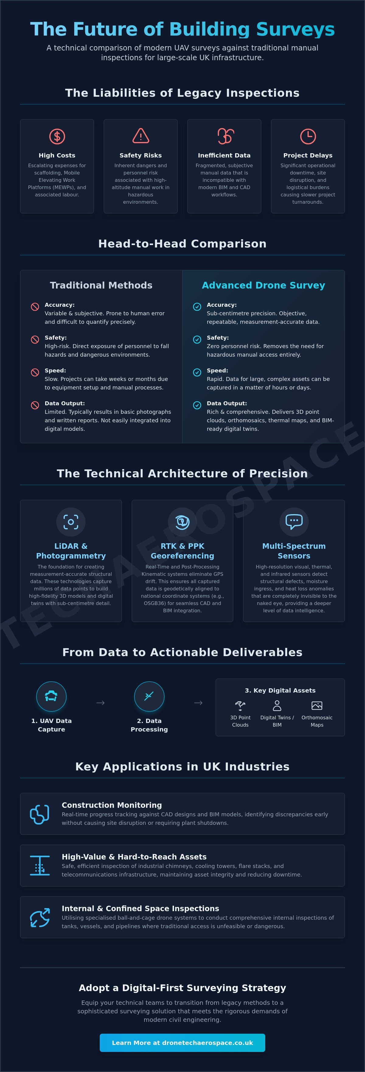
For large-scale UK infrastructure, relying on traditional scaffolding and manual inspection is no longer just a logistical burden; it's a measurable financial liability. Industry professionals recognise that the escalating costs of MEWPs and the inherent safety risks of high-altitude surveys are increasingly difficult to justify, especially when manual data remains fragmented and incompatible with modern BIM workflows. This guide demonstrates how an advanced drone building survey replaces these outdated methods with high-precision digital twins, offering centimetre-level accuracy whilst eliminating the need for hazardous manual access.
We will examine the technical integration of UAV-captured data into CAD environments, the impact of the 2026 UK drone regulations on commercial operations, and the specific methodologies used to achieve zero-risk inspections of complex industrial assets. By moving beyond simple aerial photography into geodetically accurate data harvesting, organisations can achieve faster project turnaround times and a significant reduction in operational risk. This professional overview ensures your technical teams are equipped to transition from legacy inspection methods to a sophisticated, digital-first surveying strategy that meets the rigorous demands of modern civil engineering.
Key Takeaways
Understand the technical distinction between standard aerial imagery and a measurement-accurate advanced drone building survey that utilises LiDAR and photogrammetry for sub-centimetre precision.
Learn how RTK (Real-Time Kinematic) and PPK (Post-Processing Kinematic) technologies eliminate GPS drift, ensuring that structural data is geodetically aligned for BIM and CAD integration.
Identify the operational advantages of removing scaffolding and MEWPs from the inspection process, which significantly reduces project lead times and mitigates personnel risk in hazardous environments.
Explore the transition from raw data to actionable assets, including the generation of high-resolution 3D point clouds and scale-accurate orthomosaic maps of building facades.
Discover the specific application of specialised ball-and-cage drone systems for conducting comprehensive internal inspections within confined spaces where traditional access remains unfeasible.
Table of Contents
Defining the Advanced Drone Building Survey: Precision Beyond Photography
The Technical Architecture of High-Accuracy UAV Building Inspections
Strategic Advantages: Why Advanced UAV Surveys Outperform Traditional Access Methods
From Data to Deliverables: 3D Models, Orthomosaics, and BIM Integration
Drone Tech Aerospace: Delivering National Industrial Surveying Excellence
Defining the Advanced Drone Building Survey: Precision Beyond Photography
The term advanced drone building survey refers to a sophisticated data-harvesting operation that utilises Unmanned Aerial Vehicles (UAVs) equipped with high-specification sensors. Unlike standard aerial photography, which provides only visual context through simple imagery, an advanced survey generates measurement-accurate structural data. This is achieved through the application of photogrammetry or Light Detection and Ranging (LiDAR) technology. These systems capture sub-centimetre accurate details, creating the necessary foundation for high-fidelity 3D models and digital twins.
Standard aerial photography is often limited to qualitative assessments; it shows that a defect exists but cannot define its precise dimensions or spatial position. In contrast, technical surveying provides geodetic accuracy. This ensures that every captured data point aligns precisely with national coordinate systems, such as the Ordnance Survey National Grid (OSGB36). This alignment is essential for engineering and architectural applications where spatial precision is non-negotiable. An advanced survey represents a single source of truth, integrating thermal, visual, and spatial data into a unified dataset.
The Shift from Visual Inspection to Data Intelligence
Modern asset management has moved beyond 4K video clips to structured point cloud data. A point cloud consists of millions of individual data points, each with its own X, Y, and Z coordinates. This level of detail allows for precise volumetric measurements and structural analysis that visual inspections cannot replicate. Advanced sensors also detect moisture ingress and thermal anomalies that are invisible to the naked eye, providing early warning of structural degradation. Every piece of data is timestamped and georeferenced, which is vital for maintaining a robust audit trail for insurance and compliance purposes.
Key Applications in the UK Industrial Sector
UK industrial entities utilise these surveys to monitor large-scale construction progress without causing site disruption or requiring plant shutdowns. This is particularly effective for inspecting high-value, hard-to-reach assets such as industrial chimneys, cooling towers, and flare stacks. By applying a specialised industrial drone inspection strategy, organisations can maintain asset integrity whilst significantly reducing operational downtime. Furthermore, heritage site preservation benefits from these non-contact structural assessments, allowing for the detailed documentation of fragile masonry without the risk of physical damage from traditional access equipment.
Construction Monitoring: Real-time progress tracking against CAD designs.
High-Value Assets: Inspection of chimneys, towers, and telecommunications infrastructure.
Heritage Preservation: Non-invasive 3D documentation of historic structures.
Internal Inspections: Safe data capture within confined or hazardous spaces.
The Technical Architecture of High-Accuracy UAV Building Inspections
High-accuracy data capture depends on the synergy between airframe stability and sensor precision. For an advanced drone building survey, enterprise-grade UAVs are essential. These platforms are engineered to handle heavy payloads and maintain flight stability in the turbulent airflows often found around large industrial structures. Unlike consumer-level equipment, professional drones feature redundant systems and hardened GPS modules that resist electromagnetic interference from steel-heavy environments.
The primary challenge in aerial surveying is GPS drift, which can misplace data by several metres. To eliminate this, we utilise Real-Time Kinematic (RTK) and Post-Processing Kinematic (PPK) workflows. RTK provides live positional corrections via a base station or network, whilst PPK allows for the correction of flight data after the mission, ensuring sub-centimetre relative accuracy. To achieve absolute geodetic accuracy, Ground Control Points (GCPs) remain the industry gold standard. Whilst many providers only place GCPs on the ground, a professional-grade survey involves placing high-contrast targets at known coordinates on the building facade itself. This vertical control ensures that the resulting 3D model is perfectly aligned with the site's physical reality.
LiDAR vs. Photogrammetry for Vertical Assets
Sensor selection is dictated by the complexity of the building geometry. LiDAR (Light Detection and Range) is superior for assets obscured by vegetation or scaffolding because its laser pulses can penetrate small gaps to reach the underlying building fabric. Conversely, photogrammetry provides the high-resolution visual textures required for detailed orthomosaic mapping. Academic research into UAV 3D modeling applications suggests that the most robust digital twins are often produced through hybrid missions that combine both datasets. This approach ensures the structural precision of LiDAR is complemented by the visual clarity of photogrammetry.
Thermographic Integration for Building Fabric Analysis
Advanced surveys often incorporate thermographic sensors to identify heat loss and insulation failures that are invisible to visual cameras. This is particularly effective for industrial roofing, where thermal anomalies can indicate trapped moisture or failing membranes long before a leak manifests. Thermographic UAV surveying is a non-destructive testing (NDT) method for building envelopes that allows for a comprehensive thermal "fingerprint" of the asset without requiring physical contact. If your facility requires this level of technical oversight, implementing a bespoke industrial drone inspection strategy ensures that every thermal and structural defect is documented within a unified digital environment.
RTK/PPK Systems: Eliminating positional drift for precise data alignment.
Vertical GCPs: Ensuring absolute spatial accuracy across building facades.
LiDAR Payloads: Penetrating obstructions for accurate structural measurements.
Thermal Sensors: Detecting moisture ingress and insulation voids.
Strategic Advantages: Why Advanced UAV Surveys Outperform Traditional Access Methods
The transition from manual inspection to an advanced drone building survey represents a fundamental shift in asset management efficiency. Traditional methods, particularly the deployment of scaffolding or Mobile Elevated Work Platforms (MEWPs), introduce significant logistical bottlenecks. Scaffolding often requires weeks of lead time for permitting and assembly, whereas a UAV team can be operational within hours of arriving on-site. This speed of deployment allows for rapid response to urgent structural concerns without the prohibitive overheads associated with temporary works.
Beyond speed, the density of data captured via UAV far exceeds manual capabilities. A human inspector using traditional tools might record several hundred measurements or observations during a day-long survey. In contrast, a single drone flight generates millions of data points within a high-density point cloud. This provides a comprehensive digital record that eliminates the "data gaps" common in manual reports. Furthermore, conducting these surveys whilst sites remain fully operational ensures that industrial productivity is never compromised by the presence of inspection teams or heavy access machinery.
Deployment Speed: Traditional methods take weeks; UAV surveys take hours.
Data Fidelity: Manual surveys provide hundreds of points; UAVs provide millions.
Personnel Risk: Traditional involves high-altitude manual work; UAVs offer zero-risk remote capture.
Site Impact: Traditional often requires shutdowns; UAVs maintain operational continuity.
Cost-Benefit Analysis of Drone Deployment
The financial rationale for adopting UAV technology is grounded in the reduction of both direct and indirect costs. Whilst the day rate for a professional drone team reflects their specialised expertise, it is consistently lower than the cumulative expense of multi-week scaffolding hire and the associated labour for assembly. Proactive, frequent inspections facilitated by drones also lead to lower insurance premiums by demonstrating a rigorous approach to asset integrity. Early defect detection allows for targeted repairs, preventing the minor issues of today from becoming the catastrophic failures of tomorrow.
Accessing the Inaccessible
UAV technology excels in environments where human access is either too dangerous or physically impossible. This includes unstable heritage structures, precarious demolition sites, and complex coastal infrastructure where tidal conditions limit traditional access. For internal requirements, we utilise specialised ball and cage-drone systems. These protective frames allow the aircraft to navigate internal voids and confined spaces safely, rebounding from obstacles whilst capturing high-resolution data. This capability ensures that even the most hazardous areas of an industrial facility are inspected with absolute precision and zero risk to personnel.
From Data to Deliverables: 3D Models, Orthomosaics, and BIM Integration
Raw data collected during an advanced drone building survey is processed into structured deliverables that provide immediate utility for engineering teams. The primary output is the 3D point cloud, a dense collection of georeferenced coordinates that forms the spatial framework of a digital twin. This dataset allows for precise measurement of structural elements, such as roof pitches and facade dimensions, with a degree of accuracy that traditional 2D drawings cannot replicate. By converting raw sensor data into these structured formats, we provide a measurement-accurate foundation for all subsequent design and maintenance activities.
For detailed visual documentation, orthomosaic mapping provides high-resolution, scale-accurate 2D representations of building facades. These are geometrically corrected images where every pixel represents a known physical dimension, eliminating the perspective distortion found in standard photography. This data feeds directly into AutoCAD and Revit environments, allowing architects to work within a measurement-accurate digital replica of the site. This seamless integration ensures that as-built conditions are perfectly reflected in the project's BIM environment, reducing the risk of design errors caused by inaccurate site data.
Level of Detail (LOD) Standards for Building Surveys
Technical precision is defined by the drone survey 3D model LOD (Level of Detail) standards, which dictate the complexity of the final deliverable. Whilst LOD 200 provides a general structural outline suitable for preliminary planning, LOD 300 delivers specific component geometry and precise spatial location. LOD 300 provides the necessary detail for precise architectural renovation by documenting exact structural openings and material interfaces. Selecting the correct LOD is essential to ensure the survey meets the specific needs of architects and surveyors without incurring unnecessary processing overheads.
Digital Twins and Asset Management
Beyond the construction phase, these models serve as the foundation for long-term asset management and lifecycle tracking. Integrating survey data into Facility Management (FM) software enables estate managers to monitor the condition of industrial assets with absolute precision. The future of asset integrity lies in "live" building models that are updated through periodic UAV audits. This approach provides a historical record of structural performance, allowing for data-driven decisions regarding maintenance and capital expenditure. Professionals requiring this level of technical oversight should consider a measured building survey to establish a measurement-accurate baseline for their assets.
3D Point Clouds: High-density datasets for precise spatial analysis.
Orthomosaic Maps: Scale-accurate 2D facade documentation.
BIM Integration: Direct data flow into Revit and AutoCAD.
LOD Compliance: Adherence to international Level of Detail standards.
Drone Tech Aerospace: Delivering National Industrial Surveying Excellence
Drone Tech Aerospace operates as a premium partner for corporate and industrial entities requiring sophisticated aerial data harvesting. Our approach to an advanced drone building survey is rooted in technical precision and professional accountability. We provide comprehensive national coverage, ensuring that high-stakes assets across the UK are documented with absolute reliability. This expertise is codified in our industrial drone inspection strategy, a framework designed to ensure every mission aligns with international standards for asset integrity and structural safety. We don't provide simple photography; we deliver engineering-grade datasets.
The business maintains a clear distinction from standard market providers through our operational scale and technical depth. Every project is managed with a focus on results, ensuring that the transition from raw data capture to BIM-ready deliverables is seamless and logical. By positioning ourselves as a high-performance partner, we reassure our clients that their complex requirements will be handled with professional precision. This commitment to quality is what allows us to operate at a different level than less specialised competitors in the UK market.
Specialised Confined Space and Internal Surveys
A significant gap in traditional surveying is the inspection of internal voids and hazardous confined spaces. Drone Tech Aerospace utilises advanced ball and cage-drone systems to navigate internal tanks, industrial chimneys, and heritage voids safely. These aircraft are engineered to operate in GPS-denied environments, allowing for the collection of high-resolution visual and spatial data where traditional UAVs would fail. This capability provides a complete structural record of previously unreachable areas, ensuring that internal defects are identified without the need for human entry into dangerous environments.
Why Industry Leaders Partner with Drone Tech Aerospace
With over a decade of experience in technical aerial surveying, the brand has developed proprietary methods that ensure geodetic accuracy on every project. Our bespoke solutions are tailored for the specific demands of civil engineering, renewable energy, and heritage preservation sectors. We prioritise the delivery of measurement-accurate 3D models and integrated thermal analysis, providing the clarity required for high-stakes decision-making. Our commitment to professional standards ensures that all data is structured for immediate integration into existing CAD and BIM workflows.
National Operational Scale: Professional survey teams available for large-scale UK infrastructure.
Confined Space Expertise: Safe internal inspections using specialised cage-drone technology.
BIM-Ready Deliverables: Data structured for direct integration into Revit and AutoCAD.
Technical Authority: Over ten years of proven experience in high-stakes industrial environments.
Integrated Thermal Analysis: Combining visual and thermographic data for comprehensive building fabric assessment.
Advancing Structural Integrity Through Digital Innovation
The integration of high-fidelity UAV data into structural asset management is no longer a future prospect; it's a current operational standard for industry leaders. By transitioning to an advanced drone building survey, organisations secure geodetically accurate digital twins that facilitate precise BIM integration and long-term lifecycle management. This methodology effectively eliminates the logistical constraints of traditional access whilst providing a density of data that manual inspections cannot replicate.
Drone Tech Aerospace provides the technical authority required for these high-stakes missions. With over 10 years of industrial surveying experience, our CAA-certified specialised UAV pilots utilise proprietary internal cage-drone technology to inspect the most inaccessible environments. We ensure that every deliverable meets rigorous technical standards for accuracy and professional accountability. This level of precision provides the security and assurance necessary for managing complex, large-scale UK infrastructure.
Contact Drone Tech Aerospace for a Professional Building Survey Consultation to establish a measurement-accurate foundation for your next infrastructure project. We look forward to supporting your technical objectives with absolute precision and proven expertise.
Frequently Asked Questions
What is the accuracy of an advanced drone building survey?
An advanced drone building survey typically achieves sub-centimetre relative accuracy when utilising high-resolution photogrammetry or LiDAR sensors. Absolute geodetic accuracy is maintained within a 10mm to 30mm range through the deployment of Ground Control Points (GCPs) and Real-Time Kinematic (RTK) positioning. This level of precision ensures that the resulting digital twin is suitable for rigorous architectural design and engineering tolerances.
Do I need to vacate the building during a drone survey?
No, building evacuation is not required during the data capture process. UAV operations are non-invasive and conducted whilst the site remains fully operational, avoiding the disruptions associated with traditional scaffolding assembly. Our pilots maintain strict safety cordons to ensure that personnel and public activities continue without interruption whilst external facades and roof structures are inspected with precision.
How long does it take to receive the survey data?
Standard data processing times range from three to five business days for initial orthomosaics and visual reports. Complex 3D point clouds and BIM-ready models may require additional processing time depending on the required Level of Detail (LOD). This timeline remains significantly faster than traditional manual surveying methods, which often involve weeks of data collation and manual drafting before a final report is issued.
Can drones perform internal building inspections in confined spaces?
Yes, specialised internal and confined space inspections are conducted using protective ball or cage-drone systems. These aircraft are designed to navigate GPS-denied environments such as storage tanks, chimneys, and service voids without risking structural damage. This technology allows for the capture of high-resolution visual and spatial data in areas that are otherwise inaccessible or hazardous for human inspectors to enter.
Are drone surveys compliant with UK health and safety regulations?
All operations are fully compliant with Civil Aviation Authority (CAA) regulations and wider UK health and safety standards. Professional drone surveys significantly reduce site risk by removing the need for personnel to work at height or in hazardous areas. We provide comprehensive risk assessments and method statements (RAMS) for every mission, ensuring that all flight activities meet rigorous corporate compliance and insurance requirements.
What file formats are provided for 3D building models?
Deliverables are provided in industry-standard formats to ensure seamless integration with CAD and BIM software. Common formats include .LAS or .LAZ for point clouds, .OBJ or .FBX for textured 3D models, and .DWG or .RVT for architectural drafting and Building Information Modelling. This compatibility ensures that the advanced drone building survey data is immediately actionable for structural engineers and architects within their existing digital workflows.
How does weather affect the scheduling of a drone building survey?
High winds exceeding 20mph or heavy precipitation will necessitate the rescheduling of flight operations to ensure data quality and aircraft safety. Whilst enterprise-grade UAVs possess high wind resistance, optimal results are achieved in stable conditions with consistent lighting. We monitor meteorological data closely to identify suitable flight windows, ensuring that surveys are completed with maximum technical precision and minimal operational delay.
Is a drone survey cheaper than traditional scaffolding?
Drone surveys are generally more cost-effective than traditional scaffolding, as they eliminate the high costs of equipment hire, labour for assembly, and the logistical overheads of site downtime. Industry data suggests that UAV-based assessments can be significantly less expensive than ground-based methods for large-scale infrastructure. By reducing the inspection window from weeks to hours, organisations can reallocate resources more efficiently across their asset management portfolios.


Comments